The German media giant MairDumont supplies bookstores in Western Europe with maps and guidebooks that mark Ukraine’s internationally recognised borders as “disputed” with Russia.
On the eve of the new school year, Ukrainian refugee Nina, who fled to Austria because of the war, decided to buy her 12-year-old son a geographical atlas, according to a journalistic investigation by the Ukrainian edition of the BBC. She decided on a large, solid hardback edition, sold in one of the largest bookstores in Vienna. But she could not believe her eyes when she examined the purchase at home.
“I started looking at the map of Europe and saw some dotted lines in the middle of Ukraine. At first, I didn’t understand what it was, but then I looked at the transcript, and it turned out that the east and south of Ukraine were ‘disputed territory’,” Nina recalls. “I was just shocked. I didn’t even show the atlas to my child. Because how can I explain to him why our country is divided into parts like this in this book?” – she adds.
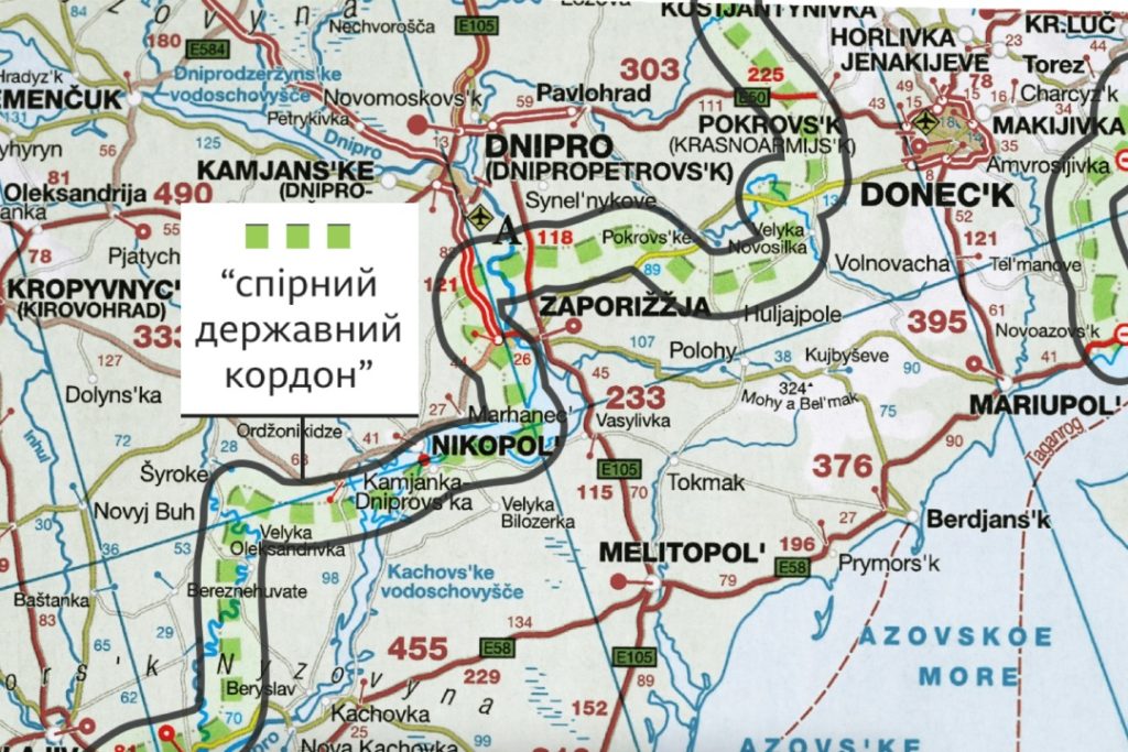
The atlas Nina bought was published by the German publishing house Kunth in 2023. In it, five regions of Ukraine – Zaporizhzhia, Kherson, Donetsk, Luhansk, and Crimea – are marked with a dotted line as the territory with a “disputed state border”. The same dotted line also marks the entire eastern border with Russia in the Donbas and Crimea.
“It’s like a knife in the heart. My mother and brother are now in the occupied territory – in Mariupol. I am from there. A rocket hit our yard, the house is cracked, and there is no communication”, said Nina.
The territories depicted in the atlas as disputed with Russia are precisely those regions in which the Kremlin, in addition to Crimea, occupied in 2014, has illegally declared “Russian”.
On 30 September 2022, President Vladimir Putin signed “agreements on accession to the Russian Federation” of the new entities – Donetsk, Luhansk, Kherson and Zaporizhzhia regions.
Subsequently, Russia began to issue maps showing all five regions of Ukraine as part of Russia. This included Ukrainian towns and villages that had never been under Russian occupation.
“I’m from Zaporizhzhia myself; it’s a huge city. It was never occupied for a single day; no Russian soldiers were there. But on Russian maps, it is in Russia, and on German maps, it is on ‘disputed territory,'” says Mykola Holubey, founder of the Stop Mapaganda project. – “So is Kherson, liberated from the Russians in November 2022. It is also on these maps in the “disputed territory”. As for me, this is the legalisation of the so-called Russian “referendums” of autumn 2022.”
Mykola Holubey visited 30 bookstores in Germany, Austria and Switzerland. He bought dozens of wall maps and atlases for drivers and tourist guides, where, according to him, the territory of Ukraine is incorrectly depicted. Among the publishers of such products are other German brands with a worldwide reputation, such as ADAC and Marco Polo, as well as the Swiss publishing house Kümmerly+Frey.
Mykola has assembled a collection of atlases and globes where, according to him, the territory of Ukraine is incorrectly depicted.
On all the maps from 2023 that he shared with the BBC, a dotted border separating Crimea and four southeastern regions from the rest of the country is drawn across Ukraine as if it were a copycat.
The BBC found that all the above brands are part of the same group – MairDumont GmbH & Co. KG. This German giant is the country’s largest travel publishing group, headquartered in Ostfildern, near Stuttgart.
According to the German Commercial Register, MairDumont includes over a dozen companies. Among them are Switzerland’s leading travel publisher, Hallwag Kümmerly+Frey, an independent subsidiary of MairDumont, and the well-known Marco Polo brand, one of the most popular guidebooks in Germany and Europe.
“Over 25 years, more than 100 million Marco Polo guidebooks have been sold. One in four guidebooks bought in Germany is a Marco Polo,” the official MairDumont website boasts.
MairDumont products can be easily found on the shelves of shops in Western Europe. Their maps and atlases are sold through the largest bookstore chains in Germany, Switzerland, and Austria, which include almost 1,000 stores.
Their products are also available in bookshops in the UK. The BBC found and purchased atlases published in 2023 by Marco Polo and Kompass (another MairDumont brand) in the London branch of the world’s largest map shop, Stanfords.
“Legitimising Russian claims” on the maps
This is not the first time that Ukraine’s territory has been misrepresented. After the annexation of Crimea in 2014, certain map publishers, including the well-known National Geographic, began to depict the peninsula as disputed or even part of Russia in violation of international norms. However, the maps published by MairDumont for the first time labelled the unoccupied territories of Ukraine as “disputed”.
“The ‘disputed area’ label implies some dispute between the countries that must be resolved. But in this situation, there is no dispute! Since 1991, it is clear that Ukraine has defined state borders,” says Klaus Dodds, Professor of Geopolitics at King’s College Holloway, London, and author of Border Wars.
“So what do these maps do? They somehow legitimise Russia’s encroachment on Ukrainian territory. That’s why it’s so dangerous! It’s a reproduction of cartographic propaganda by third parties,” the professor concluded.
On the last pages of its atlases and guides, MairDumont warns readers in tiny letters: “We revise each edition according to the latest data, taking into account the current de facto political control of the territories.”
MairDumont refused to be interviewed. Instead, they sent the BBC their official statement, which they had previously sent to the Ukrainian embassies in Switzerland and Germany following a request from Ukrainian diplomats.
MairDumont notes that it recognises all five regions as the territory of Ukraine but uses a dotted line to denote the “de facto conflict zone”. “We believe it is our duty to inform our clients about the current situation on the ground in case of conflicts, etc…..” the statement reads.
However, the experts the BBC spoke to disagree with this explanation. They argue that if the company intended to warn its readers about the potential danger, it should have depicted the entire territory of Ukraine as a war zone and added appropriate labels and decipherment. And this is not present in the atlases.
“These maps are misleading,” explains Professor Dodds. “If you are justifying the Russian invasion of Ukraine, then this map will make you very happy. But if you believe this is a barbaric, illegal invasion, it will be obvious that this is truly terrible cartographic production.”